WARNING - This is a draft and is work in progress. Nothing in this draft should be relied upon. Please email HCERA if you notice mistakes or have suggestions for improvements or additions.
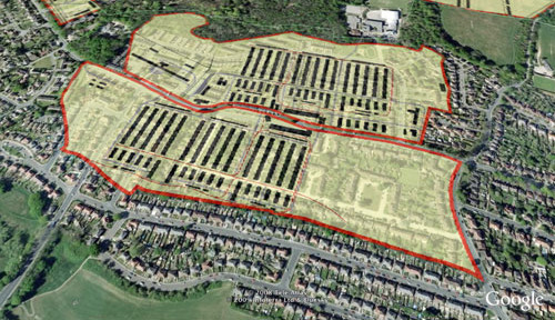
BOUNDARY OF CONSERVATION AREA
All properties within the boundary are covered by a Direction under Article 4 of the General Development Order 1988 with the exception of infill development and flats. Southampton City Council as Local Planning Authority retains control over development affecting flats as they do not have 'permitted development' rights.
PART 1
ETHELBURT AVENUE CONSERVATION AREA APPRAISAL
ASSESSING SPECIAL INTEREST
LOCATION AND SETTING
The Conservation Area is located in the north-east of the city, bounded surrounded on all sides by mid-late 20th century development ranging from detached and semi-detached early 20th-century ‘villas’ to 1970s council housing.
HISTORIC DEVELOPMENT AND ARCHAEOLOGY
Archaeology…
The Southampton Historic Environment Record (HER) shows little direct information relating to this area (although the Conservation Area itself forms a part of the HER). There are a number of tantalising Roman and earlier findspots in the vicinity, but nothing that would directly suggest that the Conservation Area was anything other than farmland, with perhaps scattered prehistoric settlement. The absence of modern development (and therefore the absence of any opportunity to carry out archaeological fieldwork) means that it is not possible to make any certain interpretations regarding the archaeology of the Estate.
The 1867 map of the area shows that at this time the Bassett Green Conservation Area was farmland. This is also probably the case with earlier maps, but the level of detail recorded is not sufficient to make any clear judgement. What became the southern boundary of the gardens in Ethelburt Avenue is marked by a track, leading to Bassett. This track has become at least partially defunct by the time of the 1909 map, but the line of the track is fossilized by a field boundary.
It is probable that the line of Bassett Green Road fossilizes part of the old road from the Sussex coast to Salisbury Plain, heading to a river crossing at Mansbridge.
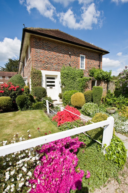
The Bassett Green Estate was originally developed in the late 1920s and early 1930s. About 100 houses were initially built by Stoneham Estates and funded by Swaythling Housing Society which was founded by Herbert Collins to provide houses to let at low rents. It comprises Ethelburt Avenue, Stoneham Lane, Bassett Green Road, Field Close, Leaside Way and Summerfield Gardens. The last dwelling to be constructed was in the late 1950s, by which time 220 houses and flats had been erected.
The land on which the CA is built was formerly part of the Fleming Estate in the parish of North Stoneham. In 1925, William J Collins, Herbert's father bought from John Willis Fleming most of the land that had comprised the South Camp of the Swaythling Remount Depot.
Before the First World War, the part to the south of Bassett Green Road was allotments and prior to that was mostly arable land forming part of Burgess Street Farm. The tithe map, about 1845, shows that there had also been a small wood on the west side, adjacent to Bassett Green Road. The Burgess Street Farm house was opposite what is now Langhorne Road. The land to the north of Bassett Green Road had been arable fields of Underwood Farm, with a very narrow strip of woodland beside Bassett Green Road. The Underwood Farm house was near the entrance to Greenways and was not demolished until 1938.
W.J. Collins offered ten acres to the nearby
Swaythling Housing Society, who built about a hundred houses on the site
in the late 1920s and early 1930s. Some of the houses were let but most
were sold and provided much-needed income for the Society. W. J.
Collins retained the freehold and the houses were sold on 999 year
leases, subject to an annual ground rent. Communal areas and greens were
leased to the Society, who are still responsible for their
maintenance.
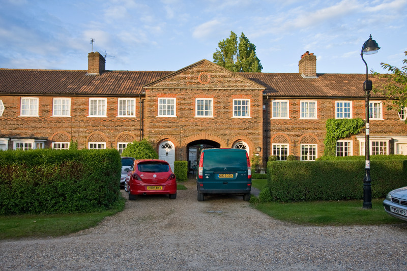
The first houses were built along the eastern boundary of the site in
Stoneham Lane, where nos. 25-27 bear a plaque dated 1927. These are
similar to houses in the Uplands Estate, in classic 'Collins' style:
mellow dark red brick, handmade plain clay tiled roofs, small paned
casement windows and well proportioned neo-Georgian doorcases. Herbert's
partner in his practice, John G. Birkett, lived at number 23 from 1927
to 1938.
The corner of Stoneham Lane and Bassett Green Road is marked
with a 'L' shaped block of two storey flats and houses, set back behind a
group of trees on a small square green. Development continued up
Bassett Green Road, including two pairs of houses with attic
storeys.
The site at Bassett Green was relatively flat and treeless, and did not
offer the same potential for site planning as the Uplands Estate. A
road, Ethelburt Avenue, was made into the site, running westwards from
Stoneham Lane then turning through 90° to connect with Bassett Green
Road. The name 'Ethelburt' was derived, not from historical sources as
one might expect, but from a combination of 'Herbert' and his sister's
name 'Ethel'. The road is unmade, with a rough gravel surface bordered
by grass verges and trees, reminiscent of early Letchworth. Houses on
the north side of Ethelburt Avenue are grouped to form three squares of
varying sizes, each open to the south. Although the houses are all
similar in size and have certain features in common, they present a
fascinating range of styles, all designed by Herbert Collins. Working
chronologically from the 'correct' Georgian-style houses in Stoneham
Lane, there are the less assertively neo-Georgian group (nos. 2 to 16
Ethelburt Avenue) with roughcast walls, half-glazed front doors and
external shutters to some windows. Opposite, nos. 5 to 39 were built of
red brick in three terraces around a formal green. A footpath between
houses in the north-east corner leads to a small pavilion and two grass
tennis courts. The south side of the Avenue continues with a series of
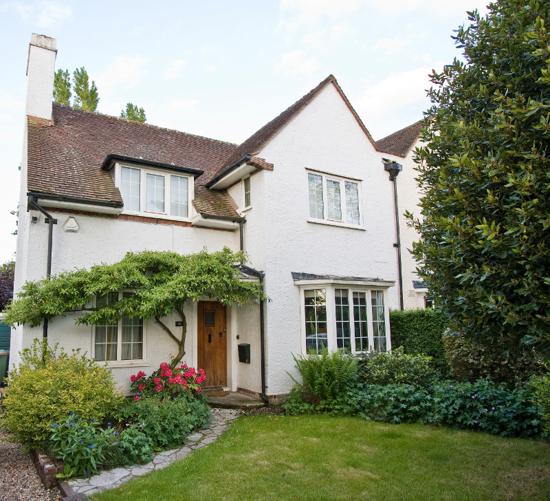
rendered detached and semi-detached houses in a neo-vernacular cottage
style, similar to early examples at Letchworth.
Further along the south side of Ethelburt Avenue are two terraces in a classical style: the projecting central section of one terrace is surmounted by a gable in the form of a massive triangular pediment.
In contrast, the houses in two small squares opposite are in a version of 1930s 'Moderne', with metal casement windows with horizontal glazing bars and curious front doors incorporating three wide horizontal glazed panels. These are dated 1933.
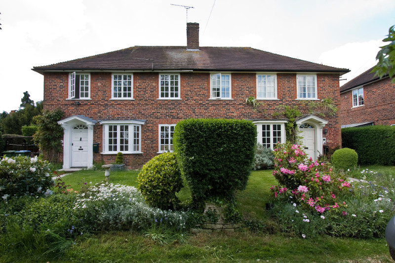
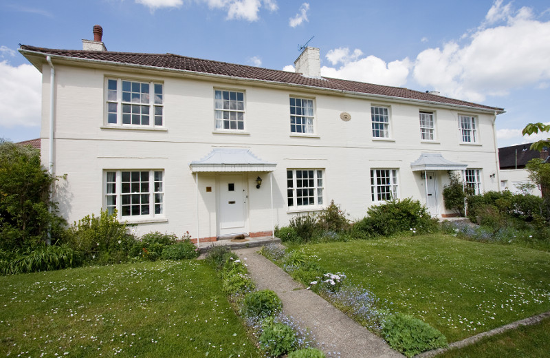
The houses on the outside of the 90° bend return to a neo-vernacular cottage style with steep-pitched roofs and dormer windows. Housing continues along the west side of Ethelburt Avenue to the junction with Bassett Green Road, with a series of modest semi-detached neo-Georgian pairs. Land on the east side remained vacant until after the Second World War where nos. 97 to III Ethelburt Avenue were built, with stuccoed walls, sliding sash windows, metal canopied porches and 'patera' ornaments supplied by Herbert's brother William.
The Bassett Green Estate also includes the houses in Bassett Green Road
between Ethelburt Avenue and Stoneham Lane, Field Close and Leaside Way.
The first houses in Leaside Way, built in 1934, are simple flat-fronted
semi- detached pairs.

They were the first Collins houses to be built with central heating and had a solid fuel boiler built under the quarter landing of the stairs. As a consequence, the stairs were built of concrete, with rubber treads and nosings.
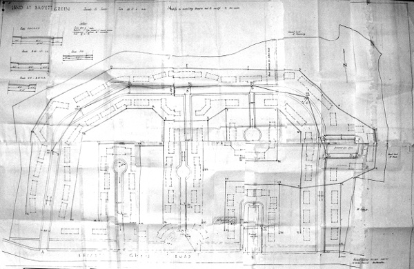
The land acquired by W.J.Collins on the north side of Bassett Green Road extended up to and including the east block of today's Ventnor Court. The above plan shows the intended development. We see that on the north east corner of Leaside Way, there was to be a terrace, but this was changed to two pairs of semi-detached houses to provide an entrance for the future Summerfield Gardens. The last houses to be built were those in the square on Bassett Green Road, built in 1938. The houses on this part of the estate were built by Ralph Collins, Herbert's brother. After the war, the land that was still undeveloped, was required by the Council for temporary housing, "prefabs". It was sold to the Council in September 1946.
In 1960 the land for Summerfield Gardens was sold to the builder A.E.Tizzard. The conveyance contained covenants to ensure that the development was according to the plans designed by Herbert Collins and there were restrictive covenants on the owners of the properties concerning alterations, including covenants to prevent enclosure of the front gardens and alteration of the colour of the paintwork from cream, except for the front doors.
In 1938 a brochure 'The Model Estate of Bassett Green' was issued for
prospective purchasers. It was printed and illustrated by Martyn
Collins, son of Ralph Collins, who later became an architect himself.
The booklet outlined points to look for when inspecting the houses and
included notes on their planning and design:
"The keynote of our policy is to keep the design as simple and direct as
possible thereby not only producing a house which is conspicuous for
its solid and sturdy appearance, but actually saving money which may be
applied to the use of the best materials. We believe that many
purchasers prefer this to the cheap showiness together with a somewhat
rickety appearance which, alas! is the leading characteristic of most
speculatively built houses."
CHARACTER ANALYSIS
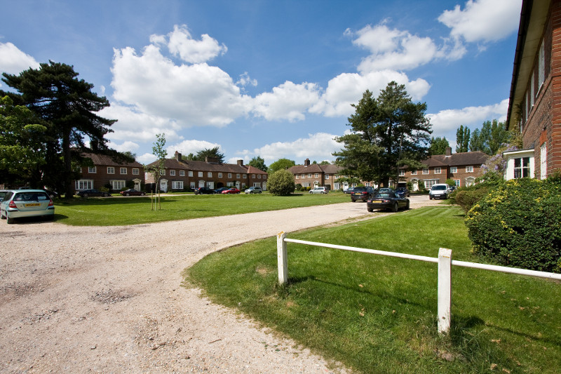
Ethelburt Avenue still retains the intended tranquil, semi-rural character, with its rough gravel road surface bordered by grass verges and trees, similar to the early garden cities. The Estate consists of a variation of housing designs but with common architectural features and detailing.
Today, an important part of the character of
Ethelburt Avenue is the unmade gravel road. This is probably an
historical accident. The original residents would have expected that the
road would be made up
by the Council and then adopted under the Private Street Works Act 1892.
This is anticipated in the leases which say "until the same (i.e.
footpaths and roadways) shall be dedicated to the public and accepted by
the proper Local Authority...".
In fact, the Council proposed schemes before the war and then the
war and post war austerity intervened.
In 1963, Ethelburt Avenue was put on the Council's priority list
to be made
up. With the reorganization of local government in 1974, highways became
the responsibility
of Hampshire County Council and private street works in Southampton took
a
back seat. Today the unmade state is seen as part of its character. This
comes at a cost. In dry weather traffic throws
up a lot of dust and regular maintenance is required to fill the
potholes. Teams of volunteers carry out repairs on three Saturdays per
year. Field Close is also a gravel road but being a cul-de-sac has
little traffic and rarely requires maintenance. The road around the
square on the north side of Bassett Green Road is deceptive. The absence
of kerbs and careful choice of surface dressing material retains the
rural appearance but hides a bitumen macadam road of good specification.
Leaside Way was made up
in 1955 by the Council and then adopted.
Field Close is a small cul-de-sac [to the west]
on the south side of Bassett Green Road. It
mirrors Ethelburt Avenue in the gravel road and paths, and the boundary
treatment of unenclosed front gardens is similar to that found in the two ‘closes’
in Ethelburt Avenue. It [no longer has]
does not have the swan-necked cast iron light columns
found elsewhere in the Conservation Area, very recently a Victorian
style lamp was installed, but otherwise the original features
designed by Collins survive very well.
Leaside Way joins Bassett Green Road and continues north towards St Georges Roman Catholic School. The paving and roads are modern tarmacadam, and blister paving has been inserted at various points, presumably due to the proximity of the school. Unlike Ethelburt Avenue the road is adopted by the city council. [The road retains the original s]Swan-necked cast iron street lighting columns were installed as an enhancement after the road was made a conservation area. Generally front gardens are bounded by mature privet hedges, and front gates generally follow the original designs. Half way along, on the east side, there is a square with unenclosed lawns in front of the houses. Many of the properties have wall plaques depicting animals, and No’s 2-4 have a date plaque of 1934. The road tends to be busy in term-time, with parents dropping children off from across the city.
Stoneham Lane is a busy link road [used as a short cut between Burgess Road] connecting Portwood Road to Bassett Green Road. As far as any Collins houses can be said to be typical, these are. Front garden boundaries are varied, ranging from no boundary to a variety of evergreen hedges to landscaped gardens with ornamental stone walling. No’s 35—43 address the corner between Stoneham Lane and Bassett Green Road by providing a set-back comprising a raised green with some mature trees.
Bassett Green Road is one of the main routes across the city, connecting [Burgess Road] with the M3 at Chilworth. On the south side, the properties within the Conservation Area are generally bordered by mature privet (as Leaside Way). While some have lost their front gardens to gravelled drives, many retain the original layout. There are a number of car ports, mainly constructed prior to the serving of the Article 4 Direction. No original street lights remain. The square on the north side of Bassett Green Road was built about 1938 by Ralph Collins, Herbert's brother. The gardens are unenclosed; this has been secured by the freeholder retaining the front lawns of the properties.
Prevalent local and traditional building materials